


"the Hà Giang loop": North Vietnam
two incredible days on the bike with Thanh-- the China border, drying off in a Hmong home;

Thanks for visiting Narrative Nation!
I returned to Vietnam for a solo adventure after walking the streets in my mind so many times since I visited with the family in 2019. This trip included the capital city Hà Nội; a homestay by Sông Lô (the Lô River) in Hà Giang, the country’s northernmost province bordering China; and a two-day motorbike ride on the famous Hà Giang loop. Because this is such a fascinating and exciting place, and because there is so much interesting patriotic and nationalist art and public history to consider in Hà Nội, I decided to share some photos and short videos with a few explanations here. You can follow this series from the beginning here. Enjoy!
Hello! This post continues my 3-day trip from Hà Nội out to the country’s northernmost province bordering China. After spending a day in Hà Giang city at a beautiful homestay by Sông Lô (the Lô River) and visiting “Waterfall 6” and the rice fields above the city, it was time to begin a two-day motorbike ride on the famous Hà Giang loop. On the map below, we started in the green city at the center and went north. Some of my pictures show our view of China.
My guide Thanh picked me up at 8:30 to store some things at the bike hostel, review our route, and agree on how I wanted to set up the bike for the ride. As usual, the level of thoughtful service and personalized attention in Vietnam was excellent.


The logistics:
The first thing we did was create an excellent backrest for me by wrapping my small suitcase in protective plastic and strapping it on to the rear of the bike. This was perfect since I could lean without any sense that I would fall off. The seat was pretty long, so I also had room for my small cloth bag in front of me, keeping my camera and personal items accessible the entire time. Sitting comfortably between my two bags, I was able to spend much of the time hands free and scoot back instead of sliding into Thanh. In some hairier parts of the ride, I held the luggage rack by my sides instead of grabbing on to him when he really needed to concentrate on the driving.
After reading some other traveler’s experiences before leaving the States, I decided to bring a high quality compressed gel seat pad to reduce the pressure (visible in the first picture above). I almost left it in my suitcase for fear of looking like a ninny, but I’m so glad I produced it that morning. It was a hit with the other drivers at the hostel, and another woman I met along the way was envious of my ride after a few hard hours. It was comfortable, and I could easily change positions to avoid getting sore or awakening the old herniated disc—in the end, I left the seat with Thanh as part of my tip.


As we pulled out of town, I quickly got used to the two little beeps before passing a truck, sometimes with only about a foot of clearance on the more narrow roads. Thanh pointed out that the codes on the passenger busses (picture on the right) tell him if they’re from Hà Giang or Hà Nội. Local drivers know the road well and can be trusted to stay in their lanes while coming right at you on tight downhill curves, while he slows down to give the out of town vehicles more space. He was such a well-informed and safe driver, and he also had some fun whenever it was safe.
I was able to enjoy every minute, take pictures, and let my thoughts range as wide as the huge green scene. Here are pictures and videos from the first day’s ride, about 160km from Hà Giang city to Van Dong in the far north.


Terraced rice fields and one of many small dragon fruit farms where the fruit is grown on top of a concrete post — some is sent to local markets and some is sold by the road in front of the family home.


Our first stop at a roadside coffee and juice bar — the last picture looks back at the road we had just traveled from town.
As you can hear in the short video above, there were many other riders at this stop, mostly small groups of young European backpackers. I asked Thanh for a more independent route and stops at less trafficked spots from this point on, and he was glad to alter the route a little to avoid a touristy experience. We were on our own for the majority of the time.

Quan Ba Twin Mountain is a popular photo stop just southwest of the Dong Van Karst Plateau Global Geopark. One legend of the twin mountains says they are the breasts of a fairy who fell in love with a local lute player and had his child. When she was forced to return to the heavens by an angry god, she left her breasts for her human husband to raise the child. Her milk nurtured this fertile valley, and her tears created the Mien River.


Thanh stopped into a small coffee shop with a great view and pulsing music. He seemed to know the two young women operating it. Though this was a place for young people, mainly on their phones, the dried corn is a reminder of one of the main economic opportunities in the area.


These three pictures show our descent into one of the valley towns we could see from the main road.


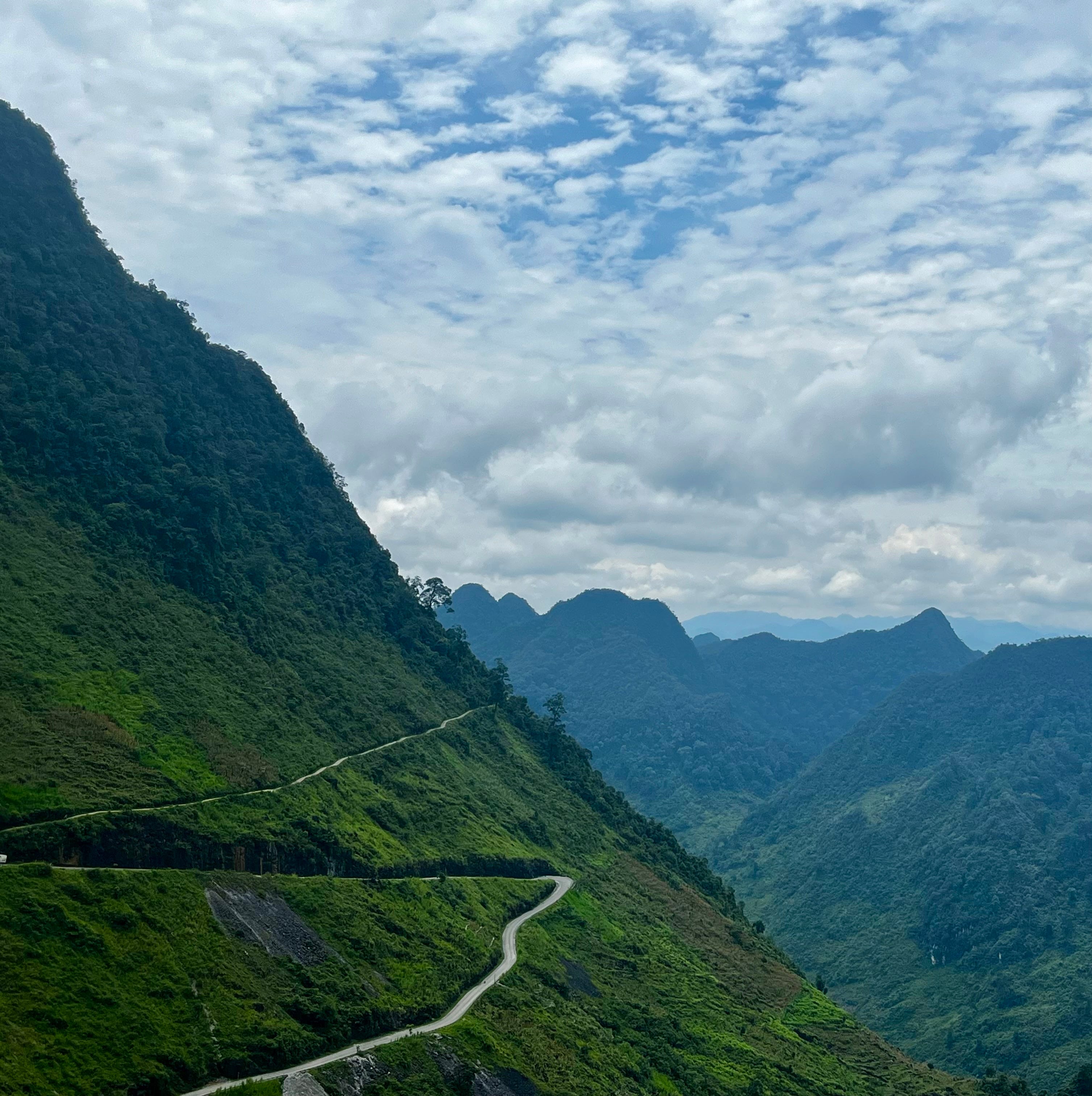
This river flowing from China looks green from the limestone that makes up this landscape of mountains and caves known as karst. After a rainy day, the color is somewhat diluted.
From this lookout, Thanh pointed out the China border and told me about the seven years it took to complete this difficult part of the road.
This bridge over a smaller river led us into one of the numerous small villages where corn was being spread out to dry by the road. Most of it is used to feed the livestock.
After a few hours we connected for lunch with two of Thanh’s crew who were taking a couple from Brighton on a three-day ride. This was one of the best meals.


These images show only a few of the dried mushrooms, root vegetables, seeds, and spice blends for sale at a roadside market. After tasting one of the sauces Thanh mixed for us at lunch, I bought some chẩm chéo, a ubiquitous Thai condiment that’s often used in northern Vietnam and Laos. It includes garlic, chestnuts, salt, lemongrass, anchovies, and various herbs.
I also captured a lot of video from the less dramatic parts of the ride, when I wasn’t using both hands to hold on during curves and steep descents. There was so much peaceful time like this, the temperature was perfect, and my thoughts were flowing freely.


This was Heaven’s Gate, and sometimes all we saw were clouds.


Here’s one of the last stops on day one, to see the memorial and leave some incense at an altar for the 14 people who lost their lives building the main road we had been traveling: Highway 4C, also known as Happiness Road.


After about 8 hours of riding, we landed at a small homestay in the somewhat happening little town of Đồng Văn, one of the most northern cities in Vietnam. There we reconnected with the others. The last picture is what’s referred to as a “Russian Jeep,” another option for people wanting to see the loop. That’s my room with the open door.
We shared hot pot for dinner, and I tried a local buckwheat ale from Tam Giac. At 80,000 VND (about $3.20 USD) it was relatively speaking one of the most expensive things I had in Vietnam! The national lagers Bia Hà Nội, Bia Saigon, and Heineken’s new Bia Viet are about 80 cents at the market and maybe $1.50 at a bar.
After dinner, Thanh and I walked a couple of blocks to the main strip where I picked a place for a 60-minute full body massage (500,000 VND, which was about 20 USD) to make sure I woke up ready for a longer second day on the bike. Thanh dipped into one of the local karaoke clubs to get a drink and wait for my call.
One more post from the loop coming tomorrow — on the second day there were some interesting experiences, and we also hit some hard rain, barely squeezed past a few recent landslides blocking the road, and dried out in a Hmong family home.
When you said « bike, » I thought you were bicycling, but then you meant motorcycle. Did you ride on the same vehicle ? Also is there concern that as you near China you will get « snatched « on some border pretext ? It sounds like an amazing adventure.